new zealand vacation, accomodation, travel information, flight, car rental

Tuesday, April 03, 2007

The Grandfather at Wai-O-Tapu, Rotorua

The following are some of the interesting features found in Wai-O-Tapu. The Oyster Pool is named after its distinct shape and it is one of the smallest pools in this geothermal park.

My New Zealand Vacation, Rotorua, Wai-O-Tapu, Photo10581
(click for larger photo)
Oyster Pool
Wai-O-Tapu, Rotorua, May 2006

Below Frying Pan Flat is an eruption crater with an unstable floor. The pool is characterized by lots of bubbling hot springs and fumeroles. The water flows from the Champagne Pool, crosses this Frying Pan Flat to emerge as a stream that flows into Lake Ngakoro.

My New Zealand Vacation, Rotorua, Wai-O-Tapu, Pano22
(click for larger photo)
Frying Pan Flat
Wai-O-Tapu, Rotorua, May 2006

Below panorama was composed from 6 photos. From the right, the water flows from the Frying Pan Flat, tumbles across the rocks and ends as Lake Ngakoro Waterfall which empties into the green waters of Lake Ngakoro, The Grandfather. Lake Ngakoro covers about 12 hectares and was formed after an eruption about 700 years ago. Notice the rough rock edges along the stream as well as the rocks littering the edge of the lake.

My New Zealand Vacation, Rotorua, Wai-O-Tapu, Pano14
(click for larger photo)
Lake Ngakoro Waterfall
Wai-O-Tapu, Rotorua, May 2006

It was raining and misty on my day of visit last May. I will surely revisit Wai-O-Tapu to see it in bright sunny weather when its brilliant colours are at their best. The thought of my next vacation to New Zealand gets me excited again! Look out for my next posting as I will introduce another interesting place in Rotorua.

Monday, April 02, 2007

Where the "Devil" Lives and Bathes at Rotorua

At Wai-O-Tapu, you will see the Devil’s Home. It is a collapsed crater which underground acid action has caused the ground to give way. You can see the grooves and rough edges caused by the acid erosion. The yellow/green colours on the walls of the crater are caused by the sulphurous fumes arising from beneath , the ground.

My New Zealand Vacation, Wai-O-Tapu, Rotorua, Photo10543
(click for larger photo)
Where the “Devil” lives
Wai-O-Tapu, Rotorua, May 2006

I took this photo from another angle which shows a tunnel at the side of this crater. I guess this is where the acidic water had flowed out and caused the ground to collapse.

My New Zealand Vacation, Rotorua, Wai-O-Tapu, Photo10544
(click for larger photo)
The tunnel leading to the “Devil”
Wai-O-Tapu, Rotorua, May 2006

The Devil’s Bath is a large crater and it is an amazing green colour! It took 4 photos to compose below panorama. Where the “home” is a drained-out crater, the “bath” is filled up and it is a result of excess water from the Champagne Pool mixing with the sulphur and ferrous salts in the ground to give the pool its amazing colour.

My New Zealand Vacation, Rotorua, Wai-O-Tapu, Pano12
(click for larger photo)
Where the “Devil” bathes
Wai-O-Tapu, Rotorua, May 2006

Primrose Terrace and Bridal Veil Falls at Wai-O-Tapu, Rotorua

The Primrose Terrace is a landform created by silica deposits. Covering an area of 3 acres, it is the largest in New Zealand since the famed Pink and White Terraces were destroyed in the eruption of Mt Tarawera in 1886. The Primrose Terrace is formed by water from the Champagne Pool which contains dissolved silica. As the water evaporates, the silica is left on the ground. It is a very gradual process of formation, very much like how stalactites and stalagmites are formed. It is estimated that the Primrose Terrace have been forming over the past 700 years since the last major geothermal activity in Wai-O-Tapu.

My New Zealand Vacation, Rotorua, Wai-O-Tapu, Pano19
(click for larger photo)
The Primrose Terrace on the left side of the boardwalk
Wai-O-Tapu, Rotorua, May 2006

On the left side of the boardwalk, the Primose Terrace is relatively flat with a down slope gradient. Towards the end of the boardwalk, the slope becomes more prominent. Below photo continues with the view of Primrose Terrace after the boardwalk crossing.

My New Zealand Vacation, Rotorua, Wai-O-Tapu, Photo10562
(click for larger photo)
The Primrose Terrace
Wai-O-Tapu, Rotorua, May 2006

It may not be apparent in above photo but there is only a thin layer of water trickling over the silica deposits. The graduated lines of the terraces can be seen in the foreground of above photo and the formation follows the pattern of water trickling down slope.

The Primrose Terrace ends with a drop and as seen in below photo, there is no longer any graduated lines of the terraces but an uneven splattering of deposits. Where this drop begins, the silica deposits has been named the Bridal Veil Falls and we can see why it was named as such.

My New Zealand Vacation, Rotorua, Wai-O-Tapu, Pano15
(click for larger photo)
Bridal Veil Falls
Wai-O-Tapu, Rotorua, May 2006

Sunday, April 01, 2007

Champagne Pool at Wai-O-Tapu, Rotorua

One of the most photographed sections of Wai-O-Tapu is the Champagne Pool. It gets its name from the constant bubbling of its water. The water fizzles and reminds of champagne though its colour is a tinge of blue and green. Along the edge of the lake, is a brilliant shade of orchre.

My New Zealand Vacation, Rotorua, Wai-O-Tapu, Pano13
(click for larger photo)
Champagne Pool
Wai-O-Tapu, Rotorua, May 2006

Unfortunately, the day I was there, it was raining and the raindrops and runoffs into the the pool had made the water murky. Otherwise, on a sunny day, the colours in the photos would have turned out brilliant!

Champagne Pool is the largest spring in the area. It has a diameter of 65m and is 62m deep! It’s surface temperature is 74 degrees Celsius and steam constantly arises from the pool. The bubbles in the pool are due to carbon dioxide, just like champagne! Like all the natural features in Wai-O-Tapu, Champagne Pool was formed by geothermal activity. From the nearby rocks found at the embankment, it is believed that the pool was formed by a hydrothermal eruption 700 years ago.

My New Zealand Vacation, Rotorua, Wai-O-Tapu, Pano19
(click for larger photo)
Crossing the Primrose Terrace on the boardwalk
Wai-O-Tapu, Rotorua, May 2006

Across the boardwalk, on the right side where the steam arises, the blue & orange shade of water indicates where the Champagne Pool is.

On the extreme right side is Artist’s Palette. When water overflows from the Champagne Pool, it brings with it minerals which are deposited on this side of the pool which results in a multitude of colours in the water. Hence, this side of the pool has been named Artist’s Palette.

On the left side of the boardwalk lies the Primrose Terrace which I will mention more in a subsequent posting.

Friday, March 30, 2007

Lady Knox Geyser at Wai-O-Tapu, Rotorua

There are two main geyser attractions at Rotorua: The Whakarewarewa Thermal Park and the Wai-O-Tapu Thermal Wonderland.

At Whakarewarewa, among the other geysers, the star is Pohutu which means “Big Splash” in Maori. If you wish to see the greatest geyser in New Zealand, then this is the one. It erupts as many as 20 times a day and reach up to heights of 30 metres. Within this thermal park, you will see bubbling mud and hot thermal springs too. If you would like to experience Maori culture too, the New Zealand Maori Arts and Crafts Institute is located in the park. You will see skilled Maori carvers and flax weavers at work. There are concert performances in the evening and you can get to experience the hangi, the traditional Maori earth oven meal.

The other main geyser attraction is at the Wai-O-Tapu Thermal Wonderland. I chose Wai-O-Tapu because besides the geyser, I had wanted to see the colourful pools and lakes of this geothermal area.

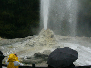
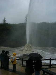
At Wai-O-Tapu, I was all excited to see the Lady Knox Geyser because it erupts daily at about 10:15am, reaching up to heights of 20 metres. It is amazing to know that even Nature has its own bio-rhythm and “clock” and keeps rather precise time too.

My New Zealand Vacation, Rotorua, Wai-O-Tapu, Lady Knox Geyser, Photo10525
(click for larger photo)
Lady Knox Geyser minutes before she blows
Wai-O-Tapu, Rotorua, May 2006

As 10:15am approached, a park warden/guide walked into the enclosed area and stood in front of the geyser. I thought it was foolish of the guide to have done that because we can never be sure of the exact moment the geyser blows. In spite of safety precautions, we should never trifle with this hot shower system. The guide went on to explain about the phenomena of geysers and this guy acted so coolly as if he had eyes behind his head to keep watch on the geyser!

It was then he revealed that someone discovered soap powder could enhance the buildup of pressure and activity which causes the geyser to erupt! This discovery could have been made by convicts who in the past were using the water for their bathing and washing. The guide proceeded to pour soap powder into the mouth of the geyser and a few moments later, Lady Knox began to regurgitate and then she finally blew up.

My New Zealand Vacation, Rotorua, Lady Knox Geyser, Photo10531
(click for larger photo)
Lady Knox Geyser blows after taking in a mouth of soap powder
Wai-O-Tapu, Rotorua, May 2006

Without soap powder, Lady Knox will not be blowing at 10:15am every day. Left on its own, its cycle varies and the interval of its next eruption could be as much as 1.5 days later.

My New Zealand Vacation, Rotorua, Lady Knox Geyser, Photo10532
(click for larger photo)
Lady Knox Geyser blows at full force
Wai-O-Tapu, Rotorua, May 2006

It was spectacular watching the force of water coming out from Lady Knox but I could not help feeling kind of cheated. Human kind has once again interfered with nature for the sake of tourism dollars! However, the amazing colours of the pools and lakes in Wai-O-Tapu more than made up for this disappointment.

Thursday, March 29, 2007

Wai-O-Tapu Thermal Wonderland, Rotorua

Wai-O-Tapu means “sacred waters” in Maori. For many tourists, the colours of the pools and lakes in Wai-O-Tapu are simply amazing!

My New Zealand Vacation, Rotorua, Wai-O-Tapu, Photo10600
(click for larger photo)
Amazing colour of a pool
Wai-O-Tapu, Rotorua, May 2006

Covering 18 square km, Wai-O-Tapu is covered with collapsed craters, cold and boiling pools of mud, water and steaming fumeroles. Beneath the ground, streams are constantly heated by magma and water has been recorded at up to temperatures of 300 degrees Celsius! The water is so hot that it absorbs minerals out of the rocks and passes out as steam at the surface which is ultimately re-absorbed into the ground. The wide range of colours of the pools and lakes in Wai-O-Tapu are due to the rich mineral content in the waters.

My New Zealand Vacation, Rotorua, Wai-O-Tapu, Photo10547
(click for larger photo)
Collapsed crater
Wai-O-Tapu, Rotorua, May 2006

Rotorua – Geothermal Hotspot

In terms of geothermal activity, Rotorua ranks as one of the most active hotspots in the world. At one of the thinnest sections, the Earth’s crust is only about 17km thick and beneath it, molten magma!

The two main attractions that people come to Rotorua to experience are its geothermal activity and Maori culture. Rotorua is a city of about 53,000 people and of which a third is Maori. The city is located on the southern shore of Lake Rotorua. In fact, Lake Rotorua with a diameter of 16 km is the circular depression of a massive volcano! If you get your hands on a topographic map, you would recognize this feature of the land. Being at Rotorua, I would not have realized this at all. So while at this city, I was actually walking and sleeping on the rim of a massive volcano! This Rotorua “volcano” is one of several large volcanoes in the Taupo region. It is estimated to have last erupted about 140,000 years ago and the magma chamber had collapsed to result in the Lake Rotorua we see today.

My New Zealand Vacation, Rotorua, Photo10521
(click for larger photo)
Hot, bubbling mud pool
Rotorua, May 2006

The attractions of Rotorua mainly revolve around hot thermal springs, geysers, bubbling mud pools and other geothermal features. You will know you will soon arrive at Rotorua when you smell a rotten-egg odour in the air! This pervasive smell is due to the sulphur fumes which arise from all these geothermal activity. You may find this smell overpowering initially and it kind of makes your head woozy. Not to worry, you will soon get used to it and perhaps you will even crack some jokes about the smell too. My coach driver was joking about passengers boarding the coach and giving him funny looks because they must be thinking that he has been farting on the trip! Kiwi humuor. :-)

My New Zealand Vacation, Rotorua, Photo10523
(click for larger photo)
Bubbling mud, contributing its share of “fart” smell in Rotorua
Rotorua, May 2006

Wednesday, March 28, 2007

Giants of the Puketi Kauri Forest

The main purpose of my vacation to the Northland in May 2006 was to see the giant Kauri tree. I had read about it and just had to see one for myself. As recent as two hundred years ago, there were still large tracts of these Kauri forests throughout New Zealand, especially in North Island. However, the arrival of the European settlers in the 1800s led to massive logging and decimated much of these ancient forests. The Kauri tree was prized for its huge size and strength of its timber and these qualities made it especially suitable for ship building. A mature Kauri tree is bare of branches at its trunk, except at its crown, so this made it particularly attractive for use as the masts of sailing ships.

The Kauri tree is a coniferous tree. Like the giant Sequoia tree of North America, the Kauri tree can grow to become a very large tree and it can live beyond a thousand years! A mature Kauri can grow to heights of 40-50 metres with trunk diameters of 3-4 metres. A young Kauri is characerised by branches along its trunk which gives it a shape of a cone (hence coniferous tree). As it grows, it continually sheds its lower branches. At maturity, branches are found only at its crown and the mature Kauri is characterized by its imposing trunk that is bare of branches.

Today, the largest area of mature Kauri forest is found in Waipoua Forest in Northland. It is a 2,500 hectare forest which contains three quarters of remaining New Zealand Kauri. The largest living Kauri, named after the Maori god Tane Mahuta, which means “God of the Forest”, has a height of 51m, trunk diameter of 4.4m and a girth of 13.3m ! Te Matua Ngahere, which means “Father of the Forest”, is believed to be the oldest living Kauri and estimated to be more than 2,000 years old! Some of the larger Kauri trees felled in the past could be older than Te Matua Ngahere.

My New Zealand Vacation, Kauri Tree, Pano34
(click for larger photo)
Giant Kauri 600-800 years old, trunk bare of branches
Puketi Kauri Forest, May 2006

Instead of Waipoua Forest, I had visited Puketi Forest to see these giant trees. That morning had begun with rain and mist. Fortunately, the mist had started to clear up when we made our way into the forest. My original photos of these trees did not turned out well and resulted in the blurred effect. I am a little disappointed that this is the best photo I have of these Kauri giants. This Kauri tree is estimated to be 600-800 years old and compared to Te Matua Ngahere, it would only be a teenager! Nevertheless, it was a great experience to have met and be awed by a living thing this old !

If you want another glimpse of the giant Kauri tree, turn on your speakers, click here for the video and don’t wait too long before you experience your magical New Zealand vacation:

100% Pure ! video (click here)

Tuesday, March 27, 2007

World Famous Mangonui Fish and Chips Shop, Doubtless Bay

Mangonui is located at the Doubtless Bay region of Northland. Once a bustling and busy whaling port, today it retains its charm as a quaint fishing village with many of its historic buildings housing restaurants, cafes, gift shops and the post office. Interestingly, Mangonui means “big shark” in Maori. However, it is not shark or its fishing industry that draws many tourists and Kiwis here but fish and chips! The star attraction is its world famous Mangonui Fish and Chips Shop which is sited along the main road and enjoys especially good business from the tour coaches.

My New Zealand Vacation, Mangonui Fish and Chips, Pano324
(click for larger photo)
World Famous Mangonui Fish and Chips Shop
Mangonui Village, May 2006

This shop has the reputation of having been voted several times as the best fish and chips in New Zealand! As it is also a fish shop which serves the locals with fresh fish every day, I guess its “secret” lies in the freshness of the fish. I quite enjoyed its fish and chips and the order came with a generous serving of chips. Usually, being famous means a premium price but the price was reasonable at this shop (though I can’t recall how much I paid for the meal).

As a fish shop, it offers many varieties of fresh fish. You will get to select which type of fish to go with your chips. You will given an order number while your meal is being cooked. Many of the tours stop at this place so be prepared to wait for your food but you will get enough time to enjoy your meal. You may wish to dine on the deck which overlooks the harbour.

I had the time to wander along the road to enjoy this peaceful scenic view. There were a few albatrosses in the air that afternoon. They would glide slowly in the air, gain some height and then suddenly plunging down into the water with a “smack”, to emerge later from the water (could even see the fish in their beaks in some instances) and then flying off. It was kind of enchanting to see them do that again and again. The memory that Mangonui left with me was that of the albatrosses gliding overhead in this peaceful scenic place and less of the fish and chips in my tummy!

My New Zealand Vacation, Mangonui Village, Pano323
(click for larger photo)
Mangonui Village, May 2006

Monday, March 26, 2007

Giant Sand Dunes at Ninety Mile Beach, Cape Reinga

Below photo was taken on the hill at Cape Reinga. The islands off the coast are the “Three Kings” which according to Maori belief is where the spirits of the deceased would turn around to have one last look at land before heading out to the open sea towards their spiritual homeland of Hawaiki. The beach on the left leads to the Ninety Mile Beach and on the other side of Ninety Mile Beach lies the Giant Sand Dunes.

My New Zealand Vacation, Ninety Mile Beach, Cape Reinga, Pano42
(click for larger photo)
The "Three Kings" off Ninety Mile Beach
Cape Reinga, May 2006

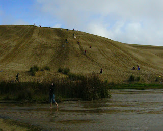
The Giant Sand Dunes are a popular tourist spot. Many tourists take the opportunity to slide down the huge sand dunes. It probably is fun playing on the sand and even though the sun was out that day, I was not too keen to join my fellow tourists. It was very late autumn, perhaps even the start of winter, and we were all wearing our jackets and shoes when we stepped out of the coach. Taking my jacket, socks and shoes off for one hour in rather cool weather is definitely not my idea of fun!

If some day you plan to see the sand dunes and have your fun too, do come prepared to get dirty and wet. Some fellas got bumped off their boards on the bottom slope and flipped over and some others could not stop in time and ended up in the stream below!

Below photo puts the size of these giant sand dunes in perspective. Be forewarned, the ride down is exhilarating but you will find it a challenge walking up the sand dune for the next ride again.

My New Zealand Vacation, Ninety Mile Beach, Giant Sand Dunes, Photo10427
(click for larger photo)
Boarding on the Giant Sand Dunes
Ninety Mile Beach, Cape Reinga, May 2006

Friday, March 23, 2007

Te Paki Quicksand at Ninety Mile Beach, New Zealand

Ninety Mile Beach (the New Zealand one) is located on the western coast of Aupouri Peninsula. It is just a short drive away from Cape Reinga. Ninety Mile Beach is not really ninety miles long. It is actually only 55 miles (88 km). How did this “error” come about? My guide explained that in the past, cattle were herded along the beach. As cattle would travel about so many miles a day (sorry, I forgot how many) and it took several days/weeks to move the cattle from one end to the other end of the beach, it was deduced that the beach was 90 miles long! Haha……

The beach is quite flat and the sand compact and firm for most parts of it, so even large vehicles like coaches could travel on it at speeds of 100km/hr. However, if you plan to self-drive on Ninety Mile Beach, you will need to be aware that rental vehicles are prohibited from being driven on the beach. Rental car companies will bring to your attention that vehicle insurance cover excludes any loss from driving on this beach. It is because there have been enough instances of visitors driving on to the Te Paki Quicksand streams and having to abandon their cars!

My New Zealand Vacation, Ninety Mile Beach, Photo10420
(click for larger photo)
Car caught on the Te Paki Quicksand streams
Ninety Mile Beach, May 2006

On my vacation in May 2006, my guide pointed out that above car got stuck in the sand just 3 weeks earlier. Any car caught on the quicksand would be completely submerged in just 2 months. Whether it was a rental car or owned, this trip would have cost that driver a hefty bit ! In the photo, you can see the sand dunes which comes right up to the beach.

Instead of self-drive, you could book one of many coach tours which include Cape Reinga, Ninety Mile Beach, boardsurfing on the giant sand dunes and a trip into the Kauri forest to meet the giants! If you book the 4x4 Dune Rider, you may wish to get into the front seat and have someone snap a photo of you in the “bikini”. ;-)

My New Zealand Vacation, Ninety Mile Beach, Photo10482
(click for larger photo)
4x4 Dune Rider, May 2006

On that day, we had the opportunity to walk on the beach, right up to the edge of the waves, to dig for Tuatuas (shellfish).

My New Zealand Vacation, Ninety Mile Beach, Photo10423
(click for larger photo)
Digging for Tuatuas
Ninety Mile Beach, May 2006

Thursday, March 22, 2007

Pacific Ocean Meets The Tasman Sea, Cape Reinga

Cape Reinga Lighthouse was built in 1941. In 1998, it became fully automated and there was no longer any need for lighthouse keepers. Today, it still serves its function as a lighthouse. It took 6 photos to compose below panorama. You can catch a glimpse of the giant sand dunes again on the bottom right corner. Cape Reinga is at the northern tip of North Island and Bluff (indicated on the yellow signpost) is at the southern end of South Island. Between them, a long journey and I traveled that distance in May-June 2006.

My New Zealand Vacation, Cape Reinga Lighthouse, Pano41
(click for larger photo)
Cape Reinga Lighthouse, May 2006

Off the cape, you can see where the Pacific Ocean meets the Tasman Sea. This meeting of the seas produces very choppy waters. Do you see the two persons at the bottom right corner of the photo? Take note of their size and you can imagine how huge those white frothy waves are!

My New Zealand Vacation, Cape Reinga, Pano319
(click for larger photo)
Pacific Ocean meets the Tasman Sea
Cape Reinga, May 2006

Wednesday, March 21, 2007

Cape Reinga, "The Leaping Place"

At the northern end of North Island of New Zealand lies Cape Reinga. It is often mistaken as the northernmost point of North Island. However, that privilege really belongs to Surville Cliffs which is some 30km away.

Cape Reinga is sacred to the Maori. In Maori language, Cape Reinga is known as Te Rerenga Wairua, which means the leaping-off place of spirits! In Maori belief, the spirits of the deceased would make their way to the cape and from this point, the spirits depart the mainland and make their journey in the afterlife to their spiritual homeland in Hawaiki. As they depart, they turn briefly at the “Three Kings” islands for one last look towards the land and then continue on their journey.

My New Zealand Vacation, Cape Reinga, Pano30
(click for larger photo)
The famous mailbox on the right
Cape Reinga, May 2006

New Zealand is often perceived as having lush greenery but at Cape Reinga you will discover a desert of giant sand dunes and quicksand! You will see the sand dunes on the left side of above photo. The “Three Kings” are the islands off the coast.

One of the things you may wish to do is to drop a postcard at the Cape Reinga mailbox. It is shown on the right of above photo. Postcards dropped at this mailbox will bear the special postmark “Cape Reinga”. There are no tourist shops around here so purchase the postcard and postage stamp prior to making this trip.

Continuing from the right of above photo is the Cape Reinga Lighthouse. While this area certainly looks like a nice picnic ground, out of respect to Maori, all visitors are requested to refrain from food and drinks on this sacred land.

My New Zealand Vacation, Cape Reinga, Pano31
(click for larger photo)
Cape Reinga Lighthouse, May 2006

Tuesday, March 20, 2007

Lord of the Rings at Deer Park, Queenstown

Finally, for the fans of Lord of The Rings (LOTR), here is a photo for you. Though having watched two of the movies, I have to admit I am no fan of the trilogy movies. However, I am a keen fan (read as fanatic) of New Zealand.

When I went up to Deer Park, it was not my intention to see the spots where the movie was filmed. My guide explained and pointed out some of the LOTR stuff but they simply didn’t register in my head! I was not paying attention and neither did I take any photos of the LOTR stuff. Instead of “Wow, LOTR!”, I was in my own fanatic world and my eyes were “Wow, Queenstown!”.

My New Zealand Vacation, The Remarkables, Deer Park, Queenstown, Pano142
(click for larger photo)
The Remarkables
Deer Park, Queenstown, Aug 2006

The above mountain range is known as The Remarkables. In The Two Towers, the scene of the Rohan refugees making their way round a pool of water was filmed at this spot with The Remarkables in the background.

The view from Deer Park is so breathtaking! Someday when you are in Queenstown, do remember to visit Deer Park to experience it for yourself; to see as far as you could see, to feel the cool breeze and to enjoy the warmth of the sun on both East & West Summit.

Your visit to Deer Park would not be complete without seeing this beautiful animal at close range:

My New Zealand Vacation, Deer Park, Queenstown, Photo20709
(click for larger photo)
Deer Park, Queenstown, Aug 2006

Monday, March 19, 2007

Spectacular View from Deer Park, West Summit, Queenstown

The East Summit view from Deer Park is not complete without this view from West Summit.

My New Zealand Vacation, Queenstown, Deer Park, Pano143
(Click for larger photo)
View from West Summit, Deer Park
Queenstown, Aug 2006

West Summit offers a good view of Queenstown. From this spot, you can see Queenstown spread out along the edge of Lake Wakatipu. In the centre foreground, the residential area of Kelvin Heights leads into the Queenstown golf course. If you golf, do remember to pack your clubs for your New Zealand vacation. There are about 400 registered golf courses in New Zealand and this makes it the country with the highest number of golf courses per capita in the world! With a population of 4 million, that means there is a golf course for every 10,000 people!

If you are seeking for Paradise, just look straight ahead and follow the mountain range in the centre of the photo. Somewhere out there lies Paradise. We hear it so often: “the answer lies in front of our eyes”. :-)

If you are seeking for golfer’s paradise, Queenstown golf course (in the centre foreground of this photo) may be your place.

Friday, March 16, 2007

Spectacular View from Deer Park, East Summit (Part II), Queenstown

In my previous posting, the photo taken on East Summit of Deer Park provided only 270 degrees view. Below photo provides the remaining 90 degrees view.

My New Zealand Vacation, Queenstown, Deer Park, Pano138
(Click for larger photo)
View from East Summit,
Deer Park, Queenstown, Aug 2006

This panorama was composed from 6 photos, 3 for the top half and 3 for the bottom half. On the left, Lake Wakatipu flows out as the Kawaura river. You see the road that crosses over the river? That is a narrow single lane bridge and it is also where you will find the first and only pair of traffic lights (one on each end of the bridge) in the whole of Queenstown / Southern Lakes district. The traffic lights were only installed in the past year.

In the centre of the photo, the distinctive straight track is the runway of the Queenstown airport. You can easily spot the airport terminal (off centre, towards the left). The houses and buildings around the airport is the township of Frankton. By strict definition, Queenstown or Queenstown CBD (central business district) is about 7 km away. Like Queenstown, Frankton is an up and coming area in the district.

At one end of the airport runway (towards the right), another river flows out to meet the Kawaura river. This is the Shotover river where you will experience the exciting Shotover jetboat rides. For the Kawaura river, the landmark bridge over it, the Kawaura Bridge marks the spot of the world’s first bungee jump.

Follow the meandering Kawaura river and you will see Lakes Hayes between the distant 2 hills. The wisp of cloud (perhaps smoke) overhanging the left hill is where Arrowtown is located.

On the right side of the photo, the edge of the mountain is The Remarkables. Using this mountain edge, piece together the above panorama with the previous panorama (270 degrees view) and experience the complete 360 degrees panorama in your mind!

The view from Deer Park is simply spectacular!

Thursday, March 15, 2007

Spectacular View from Deer Park, East Summit (Part I), Queenstown

On the East Summit of Deer Park, you will find a building of Asian architecture. This building called “The Korean Prison” was a movie set that was built in 1986 for the children’s Walt Disney movie “The Rescue”.

My New Zealand Vacation, Queenstown, Deer Park, Photo20633
(Click for larger photo)
"The Korean Prison"
Deer Park, Queenstown, Aug 2006

My guide explained that it took several months to build the movie set which cost about NZ$ 1 million. So after filming was completed, it was just abandoned. While "The Korean Prison" stands out as a unique feature and landmark in the park, there are many who see it as an eyesore marring the spectacular view on Deer Park. Since then, movie sets constructed in the park have to be removed upon completion of filming.

What will you experience on the East Summit of Deer Park? “The Korean Prison” in above photo puts this panorama into perspective. Spanning about 270 degrees, it took 10 photos to compose:

My New Zealand Vacation, Queenstown, Deer Park, Pano134
(Click for larger photo)
270 degrees view on East Summit
Deer Park, Queenstown, Aug 2006

From the left, you see The Remarkables mountain range. The sky-blue body of water is Lake Wakatipu. On the left of “The Korean Prison” is Cecil Peak and the distant Walter Peak. On the right of “The Korean Prison”, you will find Bob’s Peak and beneath the mountain range lies Queenstown. In the centre of the photo, obscured by the mound behind “The Korean Prison”, where the mountain range stretches far away into the distance, you will find this place called Paradise!

Wednesday, March 14, 2007

The Animals at Deer Park, Queenstown

In an earlier posting, I mentioned about bringing extra $1 coins to Deer Park, Queenstown but did not elaborate about this matter. The $1 coins are for the purchase of “sheep nuts” and $1 gets a full tin of this stuff. So what do you do with the “nuts”? Aha, that’s when your fun on Deer Park starts!

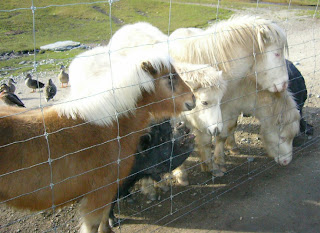
My guide called this stuff “sheep nuts”. They are actually small bits of dried food pellets. For sheep? One of the surprises at Deer Park is that besides the deer, you get to see a whole lot of other animals too. There are miniature horses, ducks, pigs, sheep, goats, alpacas, llamas …… even highland cattle and the North American bison. Calling it “The Animal Farm” would have been more appropriate!

My New Zealand Vacation, Queenstown, Deer Park, Photo20593
(Click for larger photo)
Ducks, miniature horses and ugly pigs!
“The Animal Farm”
Deer Park, Queenstown, Aug 2006

These animals roam freely on Deer Park but some are kept within fenced enclosures. To get the animals to come to you, all you have to do is shake the tin of food pellets to make a rattling sound. One of my memorable encounters was with the goats and llamas. Shook the tin and I found myself surrounded by a couple of excited llamas and goats! As the llamas are almost as tall as a man, it was a challenge trying to keep the tin out of their reach. After being jostled by a couple of them, I started to smell like them too! Haha... Unlike llamas, the alpacas are nice, gentle and well mannered.

My New Zealand Vacation, Queenstown, Deer Park, Photo20618
(Click for larger photo)
Excited llamas and goats!
Deer Park, Queenstown, Aug 2006

Feeding the animals, having them slopped saliva on your palms, you will inevitably have a good collection of exotic saliva ...... so do expect to get dirty and smell like one of the animals on your trip!

To see Pavlov theory in action, shaking a tin in Deer Park will give you a good first hand experience of frenzied salivating animals around you!

(Click below for larger photos)
My New Zealand Vacation, Queenstown, Deer Park, Photo20658
My New Zealand Vacation, Queenstown, Deer Park, Photo20662
Young Kids
1-2 weeks old
Himalayan Tarn
(beautiful long hair)


My New Zealand Vacation, Queenstown, Deer Park, Photo20720
My New Zealand Vacation, Queenstown, Deer Park, Photo20723
North American Bison
(small horns, big nose)
Highland Cattle
(big horns, big nose)

Tuesday, March 13, 2007

The Alpaca at Deer Park Queenstown

My New Zealand Vacation, Queenstown, Deer Park, Photo20597
How do I look in my new hairdo and fur coat ?
(a wolf in sheep’s clothing..... haha !)

Seriously, this woolly creature is an alpaca and it is native to South America. My first encounter with this animal was in Deer Park. It resembles a sheep but is much larger and it has a long erect neck. Like the sheep, an alpaca is covered in a thick coat of fur.

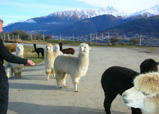
The alpaca is a beautiful creature, gentle in nature, intelligent and inquisitive. As a prey animal, it is cautious and nervous and like having its own space. In spite of encountering many visitors in Deer Park daily, the herd of alpacas was cautious with us initially and kept their distance. It took a few minutes before these animals calmed down and let us approached them.

My New Zealand Vacation, Queenstown, Deer Park, Photo20594
(click for larger photo)
Herd of alpacas at Deer Park
Queenstown, Aug 2006

In the snow-capped background, that is Queenstown below the mountain range.

Unlike the llama, the alpaca is not used as a beast of burden. It is reared mainly for its wool and meat. Compared to sheep’s wool, alpaca wool is warmer, silkier, feels more luxurious and lighter in weight. Another attractive feature, it does not contain lanolin (which the sheep has) and this makes alpaca wool almost hypoallergenic.

My New Zealand Vacation, Queenstown, Deer Park, Photo20595A
(click for larger photo)
A beautiful alpaca
Deer Park, Queenstown, Aug 2006

For ease of dyeing the wool, alpacas have been bred mainly as white. Like sheep, you will find them in many shades of colour. As you see in the photo, an alpaca’s thick coat of fur gives it an appearance of an oversized long-neck sheep!

Friday, March 09, 2007

Deer Park Heights, Queenstown

Queenstown is so exciting with so much to see and do! I have been at Queenstown more than 10 times but it was only on this recent trip that I finally made my way to Deer Park Heights. With so much exciting places to see and interesting activities to do, it is so easy to put aside Deer Park Heights. Yeah, what can be so interesting about seeing a park with a couple of deers, right? WRONG!!!

One of the sites around Queenstown for the filming of Lord of The Rings (LOTR), I had thought this place was overhyped and oversold by all the movie attention. Well, I was proven wrong. My regret, I wished I had seen it in my earlier trips! Now that you have heard it from me, put Deer Park Heights in your list of must-see when you are in Queenstown.

It is easy to get to the park, just 10 minutes drive from the heart of Queenstown. You could self-drive or join the coach tours. Travel along Frankton Road (main road which leads into Queenstown), head towards the direction of Queenstown airport, cross the narrow single-lane bridge and turn to Kelvin Heights, the premium residential area in Queenstown. You can’t miss the signboards leading to the park.

My New Zealand Vacation, Queenstown, Deer Park Heights, Photo20589
(Click for larger photo)
Welcome to Deer Park Heights
Queenstown, Aug 2006

Deer Park is a massive 800 hectares! It is a private park which still operates as a working deer farm. An entrance fee of NZ$20 per car is paid at the gate. Though walkers get in free, you would be wise to pay the $20 and drive in. If you came well prepared for tramping in New Zealand, then by all means walk in. For those on the tours, the coach will bring you into the park

Besides sunscreen, hat/cap, warm jacket, …. which are the standard pre-requisites for your vacation in New Zealand, bring along the following to Deer Park:
- 1 dollar coins (if self-drive)
- memory storage cards for digital camera (else lots of film). You will be taking lots of photos on this half-day trip!

The excitement:
My New Zealand Vacation, Queenstown, Deer Park Heights, Pano145
(Click for larger photo)
Picturesque view from Deer Park Heights
Queenstown, Aug 2006

550m above Queenstown, this place provides spectacular, 360 degrees, breath-taking views of the basins, lakes and mountain range surrounding Queenstown!

Look out for my next few postings with even more stunning photos from Deer Park!
Want more info? Search Google!
Google
the web this blog